Blaine City Council approved a draft ward boundary to be reviewed by the public during a Monday, October 10 public hearing. The boundary map would have the first ward, which covers east Blaine, extend south to the city limits east of I-5. This area is currently included in the second ward, which encompasses much of downtown.
“This plan meets all the criteria,” said Bob Schweitzer, of Sammamish Data Systems, during council’s study session. “It’s a very simple adjustment.”
The city of Blaine must evaluate its voting ward boundaries after U.S. Census population numbers are released every decade. The city hired Redmond-based Sammamish Data Systems to manage the redistricting process, which needs to be complete by November 15 to be compliant with state law. Even if housing development increases the city’s population, the city will not be able to adjust its ward boundaries again until after the 2030 census.
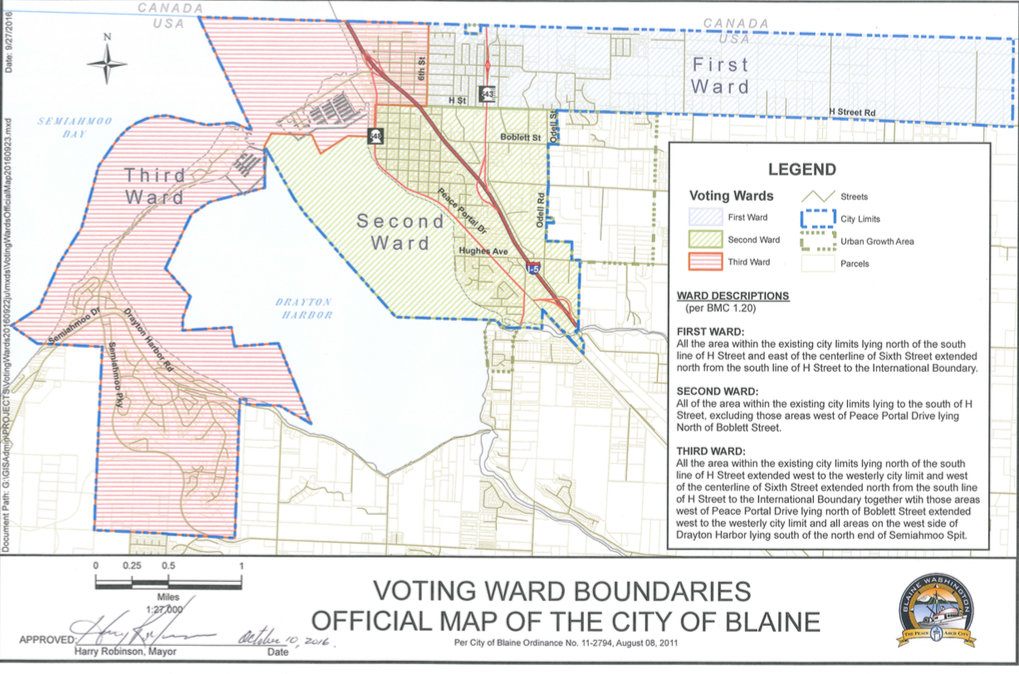
The city has three voting wards with two councilmembers for each ward and one at-large councilmember. The first ward runs west of 6th Street to city limits and between the U.S./Canada border and H Street; the second ward encompasses the downtown core west of Odell Road and runs south near the Bell Road intersection; and the third ward has Semiahmoo, a section west of Peace Portal Drive downtown, and Blaine Harbor to 6th Street.
Sammamish Data Systems presented one proposed map to council during its study session before the regular council meeting. The proposed map would bring the first ward down to the city’s southern limits, east of I-5, which is currently part of the second ward. The first ward would stay mostly the same, with the addition of a section of downtown north of Boblett Street.
The 2020 U.S. Census estimated the city’s population to be 5,884 people, which would mean each ward would ideally have close to 1,960 people. The first ward would have 31 people fewer than its ideal population, the second ward would have five people fewer than its ideal population and the third ward would have 37 people more than its ideal population, according to Sammamish Data Systems’ summary report.
Schweitzer said he first determines whether ward population sizes are as equal as possible, then if they are continuous and favor a political party or racial group. Sammamish Data Systems and the city’s attorneys will follow state law to ensure political bias does not influence the redistricting process, according to a city memo.
Mayor pro tem Richard May briefly discussed getting rid of the city’s ward boundaries and having councilmembers serve at-large, similar to Ferndale and Lynden, in the future.
“We have to do this to meet a requirement no matter what,” May said of submitting the boundary map. “The later question I want to make sure is on our minds is, we have to do this but we could come back and get rid of wards if we wanted to.”
Now that the draft boundary map is approved, the city will hold a public hearing on Monday, October 10 for residents to give their input on the map. A second public hearing could be scheduled for late October, if needed, and then council will vote on the final map.


Comments
No comments on this item Please log in to comment by clicking here